
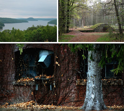
20. Prypiat, Ukraine.

Prypiat (Ukrainian: При́п'ять, Pryp’yat’; Russian: При́пять, Pripyat’) is a ghost town near the Chernobyl Nuclear Power Plant, within the Chernobyl Exclusion Zone, part of Kiev Oblast (province) of northern Ukraine, near the border with Belarus.The city has a special status within the Kiev Oblast, being the city of oblast-level subordination (see Administrative divisions of Ukraine), although it is located within the limits of Ivankiv Raion. The city also is being supervised by the Ministry of Emergencies of Ukraine as part of the Zone of Alienation jurisdiction. Pripyat was founded in 1970 to house workers for the Chernobyl Nuclear Power Plant. It was officially proclaimed a city in 1979 but was abandoned in 1986 following the Chernobyl disaster. It was the ninth nuclear city (Russian: атомоград atomograd) in the Soviet Union at the time and its population was around 50,000 before the accident[citation needed] The annual rate of natural increase for the city's population was estimated at around 800 persons, plus over 500 newcomers from all corners of the Soviet Union each year;[citation needed] Pripyat's population had been expected to rise to 78,000. The Yanov railroad station (part of Chernigov-Ovruch railroad link) was less than 1 km away from the city, and the navigable Pripyat River flows nearby.
19. Oradour-sur-Glane, France.

Oradour-sur-Glane (Occitan: Orador de Glana) is a commune in the Haute-Vienne department in the Limousin region in west-central France. The original village 45°55′44″N 001°02′24″E was destroyed on 10 June 1944, when 642 of its inhabitants, including women and children, were massacred by a German Waffen-SS company. A new village was built after the war on a nearby site but on the orders of the then French president, Charles De Gaulle, the original has been maintained as a permanent memorial.
18. Kolmanskop, Namibia.

Kolmanskop (Afrikaans for Coleman's hill, German: Kolmannskuppe) is a ghost town in the Namib desert in southern Namibia, a few kilometres inland from the port town of Lüderitz. It was named after a transport driver named Johnny Coleman who, during a sand storm, abandoned his ox wagon on a small incline opposite the settlement. Once a small but very rich mining village, it is now a popular tourist destination run by the joint firm NamDeb (Namibia-De Beers).
17. The Sanzhi UFO houses, Taiwan.

The Sanzhi UFO houses, also known as the Sanzhi pod houses or Sanzhi Pod City, were a set of abandoned pod-shaped buildings in Sanzhi District, New Taipei City, Taiwan. The buildings resembled Futuro houses, some examples of which can be found elsewhere in Taiwan. The site where the buildings were located was owned by Hung Kuo Group. However, the project was abandoned in 1980 due to investment losses and several car accident deaths during construction, which is said to have been caused by the unfortuitous act of bisecting the Chinese dragon sculpture located near the resort gates for widening the road to the buildings. Other stories indicated that the site was the former burial ground for Dutch soldiers.
16. Sewel, Chile.

Sewell is an uninhabited Chilean mining town located in the commune of Machalí in Cachapoal Province, Libertador General Bernardo O'Higgins Region, on the slopes of the Andes, at an altitude between 2,000 and 2,250 metres. The town was founded in 1904 by the Braden Copper Co. to extract the copper in the El Teniente mine, and, in 1915, it was named after the company's first president, Mr. Barton Sewell. In 1918, it already housed 14,000 people. Following many years of active life and achieving the construction and exploitation of the largest underground mine in the world, in 1977 the company started moving families to the valley and soon after the camp was being dismantled. The Chilean Government declared Sewell a National Monument in 1998, while the UNESCO designated it a World Heritage Site in 2006. Sewell is known as the city of stairs as there were no roads, only a train that brought workers and their families to the camp. Visiting the site is only allowed to tour operators, it's not possible to access the area with private vehicles. Tour operators are available in Santiago and Rancagua.
15. Pyramiden, Norway.

Pyramiden (Danish, Norwegian and Swedish meaning "the pyramid", Russian: Пирамида, piramida) is an abandoned Russian settlement and coal mining community on the archipelago of Svalbard, Norway. It was founded by Sweden in 1910 and sold to the Soviet Union in 1927. It lies at the foot of the Billefjorden on the island of Spitsbergen and is named for the pyramid-shaped mountain adjacent to the town. The settlement once had a population of over 1,000 inhabitants, but was abandoned on 10 January 1998 by its owner, the state-owned Russian company Arktikugol Trust. It is now a ghost town. Within the buildings, things remain largely as they were when the settlement was abandoned in a hurry.
14. Humberstone and Santa Laura Saltpeter Works, Chile.

In 1872, the Guillermo Wendell Nitrate Extraction Company founded the saltpeter works of Santa Laura, while the region was still a part of Peru. In the same year, James Thomas Humberstone founded the "Peru Nitrate Company", establishing the works of "La Palma". Both works grew quickly, becoming busy towns characterized by lovely buildings in the English style. While La Palma became one of the largest saltpeter extractors of the whole region, Santa Laura did not do well, as production was low. It was taken over in 1902 by the Tamarugal Nitrate Company. In 1913 Santa Laura halted its production until the Shanks extraction process was introduced, which enhanced productivity. However the economic model collapsed during the Great Depression of 1929 because of the development of the synthesis of ammonia by the Germans Fritz Haber and Carl Bosch, which led to the industrial production of fertilizers. Practically bankrupt, both works were acquired by COSATAN (Compañía Salitrera de Tarapacá y Antofagasta) in 1934. COSATAN renamed La Palma into "Oficina Santiago Humberstone" in honor of its founder. The company tried to produce a competitive natural saltpeter by modernizing Humberstone, which led to its becoming the most successful saltpeter works in 1940. Both works were abandoned in 1960 after the rapid decline that caused COSATAN to disappear in 1958. In 1970, after becoming ghost towns, they were declared national monuments and opened to tourism. In 2005 they were declared a World Heritage Site by UNESCO.
13. Bodie, California.

Bodie is a ghost town in the Bodie Hills east of the Sierra Nevada mountain range in Mono County, California, United States, about 75 miles (120 km) southeast of Lake Tahoe. It is located 12 miles (19 km) east-southeast of Bridgeport, at an elevation of 8379 feet (2554 m). As Bodie Historic District, the U.S. Department of the Interior recognizes it as a National Historic Landmark. The ghost town had been administered by California State Parks since becoming a state historic park in 1962, and receives about 200,000 visitors yearly. Starting in 2012, Bodie is administered by the Bodie Foundation, which uses the tagline Protecting Bodie's Future by Preserving Its Past.
12. Craco, Italia.

Craco is a commune and medieval village located in the Region of Basilicata and the Province of Matera in Italy. About 25 miles inland from the Gulf of Taranto at the instep of the “boot” of Italy. The medieval village of Craco is typical of the hill towns of the region with mildly undulating shapes and the lands surrounding it sown with wheat. Craco was built on a very steep summit, for defensive reasons, giving it a stark and striking appearance and distinguishing it from the surrounding lands which are characterized by soft shapes. The centre, built on the highest side of the town, facing a ridge runs steeply to the southwest where newer buildings exist. The town sits atop a 400 metre high cliff that overlooks the Cavone River valley. Throughout the area are many unique vegetation-less mounds formed by intensive erosion that are called "calanchi."
11. Beichuan Qiang, China.

Also like the other three counties and towns in Sichuan holding claims to be the birthplace of Yu the Great, Beichuan is among the most severely hit of all disaster regions following the 2008 Sichuan earthquake, including the Beichuan High School campus, where more than 1,000 students lost their lives after two main buildings collapsed. Beichuan's Party and government building also collapsed. 80% of the county's buildings are said to have collapsed. The county town, which prior to the earthquake had a population of 20,000, is to be made into a memorial park, as the site has been deemed too vulnerable. The survivors of the quake have been relocated. The earthquake also caused a landslide on Mount Tangjia which dammed the Jian River and created the Tangjiashan Quake Lake. The lake was once in danger of causing the Tangjiashan Dam to collapse and catastrophically flood downstream communities, totalling over a million persons. On June 10, 2008, the lake spilled through an artificially constructed sluice channel and flooded the evacuated town. No casualties were caused. Beichuan was at the center of one of two zones where seismic intensity were the highest at XI liedu during this earthquake and its aftershocks. Since the earthquake, the central government has increased fortification intensity for seismic design for the old county town from VI to VIII.
10. Agdam, Azerbaijan.

Ağdam (also, Agdam and Aghdam) is a ghost town in the southwestern part of Azerbaijan and the capital of its Agdam Rayon. In July 1993, after heavy fighting, Agdam was captured by the forces of the Nagorno Karabakh Republic during its 1993 summer offensives. As the town fell, its entire population were forced to flee eastwards. Many were killed by Armenian soldiers. In the immediate aftermath of the fighting, the Armenian forces decided to destroy much of Agdam to prevent its recapture by Azerbaijan. More damage occurred in the following decades when the deserted town was looted for building materials. Agdam is currently a ruinous, uninhabited ghost town. The town's large mosque survives intact but in a derelict condition.
9. Yashima, Japan.

Hard to imagine there are any ghost towns in Japan. But the Land of the Rising Sun has quite a few abandoned settlements, all well worth a visit, especially if you like quiet, creepy places. Located on Shikoku, one of the major islands of Japan, Yashima is an abandoned tourist resort that was supposed to draw tourists to the area. After all, this is one of the most important pilgrimage sites on Shikoku, with the Yashima Temple rising up at the top of the plateau. It’s also where a very important battle took place during the Genpei War, in 1185. Unfortunately things didnt quite go according to plan. The economy was surging during the 1980s and entrepreneurs around Takamatsu thought it would be a good idea to invest in tourism and capitalize on the are a spiritual reputation. They built six hotels, many other theme parks and even an aquarium.
8. Quabbin, Massachusetts.
The Quabbin Valley is a region of Massachusetts, United States. The region consists of areas drained by the Quabbin Reservoir and accompanying river systems in Franklin, Hampden, Hampshire, and Worcester counties. The area is sometimes known as the Swift River Valley region, a reference to the Swift River, which was dammed to form the reservoir.
7. Centralia, Pennsylvania.

Centralia is a borough and ghost town in Columbia County, Pennsylvania, United States. Its population has dwindled from over 1,000 residents in 1981 to 12 in 2005, 9 in 2007, and 10 in 2010, as a result of a mine fire burning beneath the borough since 1962. Centralia is one of the least-populated municipalities in Pennsylvania. Centralia is part of the Bloomsburg-Berwick micropolitan area. The borough is completely surrounded by Conyngham Township. All properties in the borough were claimed under eminent domain by the Commonwealth of Pennsylvania in 1992 (and all buildings therein were condemned), and Centralia's ZIP code was revoked by the Postal Service in 2002. However, a few residents continue to reside there in spite of the failure of a lawsuit to reverse the eminent domain claim.
6. Gulag, Rusia.

Aleksandr Solzhenitsyn, winner of the 1970 Nobel Prize in Literature, introduced the term to the Western world with the 1973 publication of his novel The Gulag Archipelago. The book likened the scattered camps to "a chain of islands" and depicted the Gulag as a system where people were worked to death. Some scholars concur with this view, whereas others argue that the Gulag was neither as large nor as deadly as it is often presented, and it did not have death camps, although during some periods of its history, mortality was high in the labor camps. In March 1940, there were 53 separate camps and 423 labor colonies in the USSR. Today's major industrial cities of the Russian Arctic, such as Norilsk, Vorkuta, and Magadan, were originally camps built by prisoners and run by ex-prisoners.
5. Varosha, Famagusta.

Varosha (Greek: Βαρώσια; Turkish: Maraş) is a quarter in the Cypriot city of Famagusta. It is located within Northern Cyprus. Prior to the Turkish invasion of Cyprus in 1974, it was the modern tourist area of Famagusta. Its inhabitants fled during the invasion, and it has remained abandoned ever since.
4. City Of Oily Rocks, Azerbaijan.
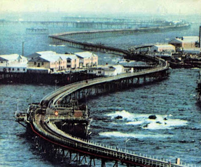
Neft Daşları (Azerbaijani: Neft Daşları, the Oil Rocks, also Neftyanyye Kamni or Neftekamni in Russian) is an industrial settlement in Baku, Azerbaijan. The settlement forms part of the municipality of Çilov-Neft Daşları in Əzizbəyov raion. It lies 100 km (62 mi) away from the Azeri capital Baku, and 55 km (34 mi) from the nearest shore in the Caspian Sea. A full town on the sea, it was the first oil platform in Azerbaijan, and the first operating offshore oil platform in the world, incorporating numerous drilling platforms. The settlement began with a single path out over the water and grew into a system of paths and platforms built on the back of ships sunk to serve as the Neft Daşları's foundation. The most distinctive feature of Neft Daşları is that it is actually a functional city with a population of about 5,000 and over 300 km (190 mi) of streets built on piles of dirt and landfill.
3. Villa Laguna Epecun, Argentina.

Laguna epecun named for the first time in 1770 by a pilot royal marines paul zizur baptized luke. Luke was a patron of medicine, and speculate that it had been named by date of parts. Located at the bottom of the depression, the water surface just reduced evaporative. Pond or Lake Epecu where n is the mirror of water belong to the basin endorheic system Encadenades West, in Buenos Aires province, Argentina. This is the sixth and last of the gaps in the system, and also the largest in the surface. Accepting donations from the Lagoon through the channel and several Paraguayan rivers such as the Pig and a large drag, down from the sierra de la Ventana. The most recent system state lagoon makes the water level varies constantly. A high concentration of saline, la laguna ten times higher than the sea, hipermarina. The water used to fight depression, rheumatic and skin and psychophysical exhaustion. The city is located on the shores of Lake Carhu. Their status oligotrophic. The condition of chemistry which water is sodium chloride hiperhalina with solids the remaining 56.75 g4 / l. this feature determine total absence of aquatic herbs and phytoplankton represented by the cyanophyta dominant: coelosphaerium aff. Pallidium. Zooplankton represented by two species of the indicators in environments with salinitas high: cladoceran and copepoda. Also appeared in a coastal area argentinus palaemonethes and small fish, shrimps jenynsia lineata, probably on tolerance limit salinitas.
2. Kowloon Walled City, Hong Kong.

Kowloon Walled City was a densely populated, largely ungoverned settlement in Kowloon, Hong Kong. Originally a Chinese military fort, the Walled City became an enclave after the New Territories were leased to Britain in 1898. Its population increased dramatically following the Japanese occupation of Hong Kong during World War II. In 1987, the Walled City contained 33,000 residents within its 6.5-acre (0.03 km2; 0.01 sq mi) borders. From the 1950s to the 1970s, it was controlled by Triads and had high rates of prostitution, gambling, and drug use. In January 1987, the Hong Kong government announced plans to demolish the Walled City. After an arduous eviction process, demolition began in March 1993 and was completed in April 1994. Kowloon Walled City Park opened in December 1995 and occupies the area of the former Walled City. Some historical artifacts from the Walled City, including its yamen building and remnants of its South Gate, have been preserved there.
1. Hashima Island, Japan.

Hashima Island (Hashima, as -shima is Japanese for island), commonly called Gunkanjima ( meaning Battleship Island), is one among 505 uninhabited islands in the Nagasaki Prefecture about 15 kilometers from Nagasaki itself. The island was populated from 1887 to 1974 as a coal mining facility. The island's most notable features are the abandoned concrete buildings and the sea wall surrounding it. The island has been administered as part of Nagasaki city since 2005; it had previously been administered by the former town of Takashima. It is known for its coal mines and their operation during the industrialization of Japan. Mitsubishi bought the island in 1890 and began the project, the aim of which was retrieving coal from undersea mines. They built Japan's first large concrete building (9 stories high), a block of apartments in 1916 to accommodate their burgeoning ranks of workers (many of whom were forcibly recruited labourers from other parts of Asia) and to protect against typhoon destruction. According to a South Korean commission, the island housed 500
 Koreans who were forced to work between 1939 and 1945, during World War II. In 1959, the 15-acre (6.1 ha) island's population reached its peak of 5,259, with a population density of 835 people per hectare (83,500 people/km2, 216,264 people per square mile) for the whole island, or 1,391 per hectare (139,100 people/km2) for the residential district. As petroleum replaced coal in Japan in the 1960s, coal mines began shutting down all over the country, and Hashima's mines were no exception. Mitsubishi officially announced the closing of the mine in 1974, and today it is empty and bare, which is why it is called Ghost Island. Travel to Hashima was re-opened on April 22, 2009 after 35 years of closure.
Courtesy by. Youtube
Source by. Wikipedia

Prypiat (Ukrainian: При́п'ять, Pryp’yat’; Russian: При́пять, Pripyat’) is a ghost town near the Chernobyl Nuclear Power Plant, within the Chernobyl Exclusion Zone, part of Kiev Oblast (province) of northern Ukraine, near the border with Belarus.The city has a special status within the Kiev Oblast, being the city of oblast-level subordination (see Administrative divisions of Ukraine), although it is located within the limits of Ivankiv Raion. The city also is being supervised by the Ministry of Emergencies of Ukraine as part of the Zone of Alienation jurisdiction. Pripyat was founded in 1970 to house workers for the Chernobyl Nuclear Power Plant. It was officially proclaimed a city in 1979 but was abandoned in 1986 following the Chernobyl disaster. It was the ninth nuclear city (Russian: атомоград atomograd) in the Soviet Union at the time and its population was around 50,000 before the accident[citation needed] The annual rate of natural increase for the city's population was estimated at around 800 persons, plus over 500 newcomers from all corners of the Soviet Union each year;[citation needed] Pripyat's population had been expected to rise to 78,000. The Yanov railroad station (part of Chernigov-Ovruch railroad link) was less than 1 km away from the city, and the navigable Pripyat River flows nearby.
19. Oradour-sur-Glane, France.

Oradour-sur-Glane (Occitan: Orador de Glana) is a commune in the Haute-Vienne department in the Limousin region in west-central France. The original village 45°55′44″N 001°02′24″E was destroyed on 10 June 1944, when 642 of its inhabitants, including women and children, were massacred by a German Waffen-SS company. A new village was built after the war on a nearby site but on the orders of the then French president, Charles De Gaulle, the original has been maintained as a permanent memorial.
18. Kolmanskop, Namibia.

Kolmanskop (Afrikaans for Coleman's hill, German: Kolmannskuppe) is a ghost town in the Namib desert in southern Namibia, a few kilometres inland from the port town of Lüderitz. It was named after a transport driver named Johnny Coleman who, during a sand storm, abandoned his ox wagon on a small incline opposite the settlement. Once a small but very rich mining village, it is now a popular tourist destination run by the joint firm NamDeb (Namibia-De Beers).
17. The Sanzhi UFO houses, Taiwan.

The Sanzhi UFO houses, also known as the Sanzhi pod houses or Sanzhi Pod City, were a set of abandoned pod-shaped buildings in Sanzhi District, New Taipei City, Taiwan. The buildings resembled Futuro houses, some examples of which can be found elsewhere in Taiwan. The site where the buildings were located was owned by Hung Kuo Group. However, the project was abandoned in 1980 due to investment losses and several car accident deaths during construction, which is said to have been caused by the unfortuitous act of bisecting the Chinese dragon sculpture located near the resort gates for widening the road to the buildings. Other stories indicated that the site was the former burial ground for Dutch soldiers.
16. Sewel, Chile.

Sewell is an uninhabited Chilean mining town located in the commune of Machalí in Cachapoal Province, Libertador General Bernardo O'Higgins Region, on the slopes of the Andes, at an altitude between 2,000 and 2,250 metres. The town was founded in 1904 by the Braden Copper Co. to extract the copper in the El Teniente mine, and, in 1915, it was named after the company's first president, Mr. Barton Sewell. In 1918, it already housed 14,000 people. Following many years of active life and achieving the construction and exploitation of the largest underground mine in the world, in 1977 the company started moving families to the valley and soon after the camp was being dismantled. The Chilean Government declared Sewell a National Monument in 1998, while the UNESCO designated it a World Heritage Site in 2006. Sewell is known as the city of stairs as there were no roads, only a train that brought workers and their families to the camp. Visiting the site is only allowed to tour operators, it's not possible to access the area with private vehicles. Tour operators are available in Santiago and Rancagua.
15. Pyramiden, Norway.

Pyramiden (Danish, Norwegian and Swedish meaning "the pyramid", Russian: Пирамида, piramida) is an abandoned Russian settlement and coal mining community on the archipelago of Svalbard, Norway. It was founded by Sweden in 1910 and sold to the Soviet Union in 1927. It lies at the foot of the Billefjorden on the island of Spitsbergen and is named for the pyramid-shaped mountain adjacent to the town. The settlement once had a population of over 1,000 inhabitants, but was abandoned on 10 January 1998 by its owner, the state-owned Russian company Arktikugol Trust. It is now a ghost town. Within the buildings, things remain largely as they were when the settlement was abandoned in a hurry.
14. Humberstone and Santa Laura Saltpeter Works, Chile.

In 1872, the Guillermo Wendell Nitrate Extraction Company founded the saltpeter works of Santa Laura, while the region was still a part of Peru. In the same year, James Thomas Humberstone founded the "Peru Nitrate Company", establishing the works of "La Palma". Both works grew quickly, becoming busy towns characterized by lovely buildings in the English style. While La Palma became one of the largest saltpeter extractors of the whole region, Santa Laura did not do well, as production was low. It was taken over in 1902 by the Tamarugal Nitrate Company. In 1913 Santa Laura halted its production until the Shanks extraction process was introduced, which enhanced productivity. However the economic model collapsed during the Great Depression of 1929 because of the development of the synthesis of ammonia by the Germans Fritz Haber and Carl Bosch, which led to the industrial production of fertilizers. Practically bankrupt, both works were acquired by COSATAN (Compañía Salitrera de Tarapacá y Antofagasta) in 1934. COSATAN renamed La Palma into "Oficina Santiago Humberstone" in honor of its founder. The company tried to produce a competitive natural saltpeter by modernizing Humberstone, which led to its becoming the most successful saltpeter works in 1940. Both works were abandoned in 1960 after the rapid decline that caused COSATAN to disappear in 1958. In 1970, after becoming ghost towns, they were declared national monuments and opened to tourism. In 2005 they were declared a World Heritage Site by UNESCO.
13. Bodie, California.

Bodie is a ghost town in the Bodie Hills east of the Sierra Nevada mountain range in Mono County, California, United States, about 75 miles (120 km) southeast of Lake Tahoe. It is located 12 miles (19 km) east-southeast of Bridgeport, at an elevation of 8379 feet (2554 m). As Bodie Historic District, the U.S. Department of the Interior recognizes it as a National Historic Landmark. The ghost town had been administered by California State Parks since becoming a state historic park in 1962, and receives about 200,000 visitors yearly. Starting in 2012, Bodie is administered by the Bodie Foundation, which uses the tagline Protecting Bodie's Future by Preserving Its Past.
12. Craco, Italia.

Craco is a commune and medieval village located in the Region of Basilicata and the Province of Matera in Italy. About 25 miles inland from the Gulf of Taranto at the instep of the “boot” of Italy. The medieval village of Craco is typical of the hill towns of the region with mildly undulating shapes and the lands surrounding it sown with wheat. Craco was built on a very steep summit, for defensive reasons, giving it a stark and striking appearance and distinguishing it from the surrounding lands which are characterized by soft shapes. The centre, built on the highest side of the town, facing a ridge runs steeply to the southwest where newer buildings exist. The town sits atop a 400 metre high cliff that overlooks the Cavone River valley. Throughout the area are many unique vegetation-less mounds formed by intensive erosion that are called "calanchi."
11. Beichuan Qiang, China.

Also like the other three counties and towns in Sichuan holding claims to be the birthplace of Yu the Great, Beichuan is among the most severely hit of all disaster regions following the 2008 Sichuan earthquake, including the Beichuan High School campus, where more than 1,000 students lost their lives after two main buildings collapsed. Beichuan's Party and government building also collapsed. 80% of the county's buildings are said to have collapsed. The county town, which prior to the earthquake had a population of 20,000, is to be made into a memorial park, as the site has been deemed too vulnerable. The survivors of the quake have been relocated. The earthquake also caused a landslide on Mount Tangjia which dammed the Jian River and created the Tangjiashan Quake Lake. The lake was once in danger of causing the Tangjiashan Dam to collapse and catastrophically flood downstream communities, totalling over a million persons. On June 10, 2008, the lake spilled through an artificially constructed sluice channel and flooded the evacuated town. No casualties were caused. Beichuan was at the center of one of two zones where seismic intensity were the highest at XI liedu during this earthquake and its aftershocks. Since the earthquake, the central government has increased fortification intensity for seismic design for the old county town from VI to VIII.
10. Agdam, Azerbaijan.

Ağdam (also, Agdam and Aghdam) is a ghost town in the southwestern part of Azerbaijan and the capital of its Agdam Rayon. In July 1993, after heavy fighting, Agdam was captured by the forces of the Nagorno Karabakh Republic during its 1993 summer offensives. As the town fell, its entire population were forced to flee eastwards. Many were killed by Armenian soldiers. In the immediate aftermath of the fighting, the Armenian forces decided to destroy much of Agdam to prevent its recapture by Azerbaijan. More damage occurred in the following decades when the deserted town was looted for building materials. Agdam is currently a ruinous, uninhabited ghost town. The town's large mosque survives intact but in a derelict condition.
9. Yashima, Japan.
Hard to imagine there are any ghost towns in Japan. But the Land of the Rising Sun has quite a few abandoned settlements, all well worth a visit, especially if you like quiet, creepy places. Located on Shikoku, one of the major islands of Japan, Yashima is an abandoned tourist resort that was supposed to draw tourists to the area. After all, this is one of the most important pilgrimage sites on Shikoku, with the Yashima Temple rising up at the top of the plateau. It’s also where a very important battle took place during the Genpei War, in 1185. Unfortunately things didnt quite go according to plan. The economy was surging during the 1980s and entrepreneurs around Takamatsu thought it would be a good idea to invest in tourism and capitalize on the are a spiritual reputation. They built six hotels, many other theme parks and even an aquarium.
8. Quabbin, Massachusetts.

The Quabbin Valley is a region of Massachusetts, United States. The region consists of areas drained by the Quabbin Reservoir and accompanying river systems in Franklin, Hampden, Hampshire, and Worcester counties. The area is sometimes known as the Swift River Valley region, a reference to the Swift River, which was dammed to form the reservoir.
7. Centralia, Pennsylvania.

Centralia is a borough and ghost town in Columbia County, Pennsylvania, United States. Its population has dwindled from over 1,000 residents in 1981 to 12 in 2005, 9 in 2007, and 10 in 2010, as a result of a mine fire burning beneath the borough since 1962. Centralia is one of the least-populated municipalities in Pennsylvania. Centralia is part of the Bloomsburg-Berwick micropolitan area. The borough is completely surrounded by Conyngham Township. All properties in the borough were claimed under eminent domain by the Commonwealth of Pennsylvania in 1992 (and all buildings therein were condemned), and Centralia's ZIP code was revoked by the Postal Service in 2002. However, a few residents continue to reside there in spite of the failure of a lawsuit to reverse the eminent domain claim.
6. Gulag, Rusia.

Aleksandr Solzhenitsyn, winner of the 1970 Nobel Prize in Literature, introduced the term to the Western world with the 1973 publication of his novel The Gulag Archipelago. The book likened the scattered camps to "a chain of islands" and depicted the Gulag as a system where people were worked to death. Some scholars concur with this view, whereas others argue that the Gulag was neither as large nor as deadly as it is often presented, and it did not have death camps, although during some periods of its history, mortality was high in the labor camps. In March 1940, there were 53 separate camps and 423 labor colonies in the USSR. Today's major industrial cities of the Russian Arctic, such as Norilsk, Vorkuta, and Magadan, were originally camps built by prisoners and run by ex-prisoners.
5. Varosha, Famagusta.

Varosha (Greek: Βαρώσια; Turkish: Maraş) is a quarter in the Cypriot city of Famagusta. It is located within Northern Cyprus. Prior to the Turkish invasion of Cyprus in 1974, it was the modern tourist area of Famagusta. Its inhabitants fled during the invasion, and it has remained abandoned ever since.
4. City Of Oily Rocks, Azerbaijan.

Neft Daşları (Azerbaijani: Neft Daşları, the Oil Rocks, also Neftyanyye Kamni or Neftekamni in Russian) is an industrial settlement in Baku, Azerbaijan. The settlement forms part of the municipality of Çilov-Neft Daşları in Əzizbəyov raion. It lies 100 km (62 mi) away from the Azeri capital Baku, and 55 km (34 mi) from the nearest shore in the Caspian Sea. A full town on the sea, it was the first oil platform in Azerbaijan, and the first operating offshore oil platform in the world, incorporating numerous drilling platforms. The settlement began with a single path out over the water and grew into a system of paths and platforms built on the back of ships sunk to serve as the Neft Daşları's foundation. The most distinctive feature of Neft Daşları is that it is actually a functional city with a population of about 5,000 and over 300 km (190 mi) of streets built on piles of dirt and landfill.
3. Villa Laguna Epecun, Argentina.

Laguna epecun named for the first time in 1770 by a pilot royal marines paul zizur baptized luke. Luke was a patron of medicine, and speculate that it had been named by date of parts. Located at the bottom of the depression, the water surface just reduced evaporative. Pond or Lake Epecu where n is the mirror of water belong to the basin endorheic system Encadenades West, in Buenos Aires province, Argentina. This is the sixth and last of the gaps in the system, and also the largest in the surface. Accepting donations from the Lagoon through the channel and several Paraguayan rivers such as the Pig and a large drag, down from the sierra de la Ventana. The most recent system state lagoon makes the water level varies constantly. A high concentration of saline, la laguna ten times higher than the sea, hipermarina. The water used to fight depression, rheumatic and skin and psychophysical exhaustion. The city is located on the shores of Lake Carhu. Their status oligotrophic. The condition of chemistry which water is sodium chloride hiperhalina with solids the remaining 56.75 g4 / l. this feature determine total absence of aquatic herbs and phytoplankton represented by the cyanophyta dominant: coelosphaerium aff. Pallidium. Zooplankton represented by two species of the indicators in environments with salinitas high: cladoceran and copepoda. Also appeared in a coastal area argentinus palaemonethes and small fish, shrimps jenynsia lineata, probably on tolerance limit salinitas.

Kowloon Walled City was a densely populated, largely ungoverned settlement in Kowloon, Hong Kong. Originally a Chinese military fort, the Walled City became an enclave after the New Territories were leased to Britain in 1898. Its population increased dramatically following the Japanese occupation of Hong Kong during World War II. In 1987, the Walled City contained 33,000 residents within its 6.5-acre (0.03 km2; 0.01 sq mi) borders. From the 1950s to the 1970s, it was controlled by Triads and had high rates of prostitution, gambling, and drug use. In January 1987, the Hong Kong government announced plans to demolish the Walled City. After an arduous eviction process, demolition began in March 1993 and was completed in April 1994. Kowloon Walled City Park opened in December 1995 and occupies the area of the former Walled City. Some historical artifacts from the Walled City, including its yamen building and remnants of its South Gate, have been preserved there.
1. Hashima Island, Japan.
Hashima Island (Hashima, as -shima is Japanese for island), commonly called Gunkanjima ( meaning Battleship Island), is one among 505 uninhabited islands in the Nagasaki Prefecture about 15 kilometers from Nagasaki itself. The island was populated from 1887 to 1974 as a coal mining facility. The island's most notable features are the abandoned concrete buildings and the sea wall surrounding it. The island has been administered as part of Nagasaki city since 2005; it had previously been administered by the former town of Takashima. It is known for its coal mines and their operation during the industrialization of Japan. Mitsubishi bought the island in 1890 and began the project, the aim of which was retrieving coal from undersea mines. They built Japan's first large concrete building (9 stories high), a block of apartments in 1916 to accommodate their burgeoning ranks of workers (many of whom were forcibly recruited labourers from other parts of Asia) and to protect against typhoon destruction. According to a South Korean commission, the island housed 500

Courtesy by. Youtube
Source by. Wikipedia


No comments:
Post a Comment